Rim Fire MAP, UPDATE 2013: Evacuation advised for Tuolumne County residents, blaze threatens power and water supply
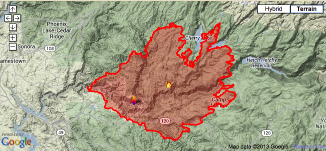
The Rim Fire, one of California's largest fires in history, continues to rage through miles of land and is dangerously encroaching on the Hetch Hetchy reservoir, which provides 85 percent of San Francisco's water supply.
224 square miles have been burned by the fire, which is in its tenth day as of Monday. Over 2,500 firefighters continue to battle the blaze, but struggling to contain it as high temperatures, dry weather conditions and winds continue.
"With the size of the fire and amount of ground we still have to cover, it's still a difficult fire," said Cal Fire Captain Mike Mohler. "We need Mother Nature to cooperate. Hopefully we'll turn the corner soon." The fire is still only 7 percent contained.
A recommended evacuation has been issued in Tuolumne County, as firefighters dug trenches and cleared brush to divert the blaze from hitting the town. Thousands of homes in the area are threatened, including 1,600 homes in Tuolumne County. The Red Cross has set up a shelter at the Mother Lode Fairgrounds in Sonora. Parts of Groveland have also been evacuated.
Yosemite National Park still remains open, but the entrance on Highway 120 on the park's west side still remains shut. Popular tourist attractions such as Yosemite Valley, Glacier Point, Wawona, Mariposa Grove, Crane Flat and Tuolumne Meadows remain open.
The raging fire not only threatens San Francisco's water supply, but the power system as well as it originates from the Hetch Hetchy reservoir as well. California Governor Jerry Brown issued a state of emergency and two hydroelectric power stations have already been shut down near Hetch Hetchy.
Lee Bentley, a spokesman with the U.S. Forest Service., told LA Times: "Everybody in this town has a right to feel nervous. This fire could always turn, depending on which way the wind blows."