Black Forest Fire evacuation MAP [UPDATE]: Mandatory evacuation zone extended, fires may grow to 11,000 acres
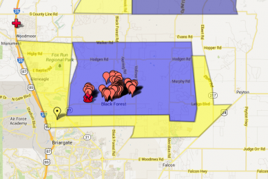
The evacuation zone for the Black Forest Colorado fire which has been raging since Tuesday has expanded to the north and west today. The fire is expected to increase up to 11,000 acres.
The northern boundary of the evacuation zone has extended to Walker Road while the western boundary extended to Highway 83, according to ABC 7.
The Elbert County Sheriff has also announced residents of southern Elbert County to evacuate from the county line north to County Road 106 on north and N. Elbert Road on the east.
Officials estimate that up to 9,500 residents are in the evacuation area.
The weather remains dry and windy, making the fire very hard to control.
A voluntary evacuation has been issued for residents of the City of Colorado Springs. The zone covers West to I-25 and all areas north of Old Ranch Road within the City limits of Colorado Springs.
See below for an updated interactive map of the mandatory evacuation zone for the Black Forest fire based on the information shared by the El Paso County Sheriff's Office.
View Black Forest Fire Evacuation Map in a larger map